


cimetière allemand

fredtruc27
User
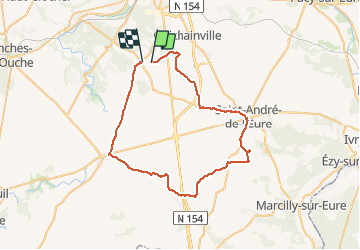

Length
51 km

Max alt
165 m

Uphill gradient
268 m
Km-Effort
55 km

Min alt
133 m

Downhill gradient
260 m
Boucle
No
Creation date :
2015-07-23 00:00:00.0
Updated on :
2015-07-23 00:00:00.0
2h20
Difficulty : Unknown

FREE GPS app for hiking
 SityTrail
IGN / Geographical institutes
SityTrail Plus
The world is yours!
About
Trail Other activity of 51 km to be discovered at Normandy, Eure, Le Plessis-Grohan. This trail is proposed by fredtruc27.
Description
ballade vélo parcours plat. cimetière allemand près de saint André
Photos


Positioning
Country:
France
Region :
Normandy
Department/Province :
Eure
Municipality :
Le Plessis-Grohan
Location:
Unknown
Start:(Dec)
Start:(UTM)
363830 ; 5424193 (31U) N.
Comments